
Hey, nothing fancy here, we are not a map clearing house or big company trying to sell subscriptions or anything like that. Really, just a one- man map mapper, hunter, backcountry enthusiast that basically wants to share with the outdoorsperson a very inexpensive option for you to put together your own collection of maps and other data. I see myself more as a consultant to a hunter, if you will, and I encourage a personal interaction between a hunter that wants a custom map made to their area of interest and the kind of map data they would like on their map.
In addition, the majority of the data I use is free on the internet from various sources and if you want to dabble in learning and manipulating your own data I am here to
help. What allows me to use much of this data and manipulate in various ways, I use professional GIS software which is not cheap nor always that easy to use. Now, I have been using the software platform for over twenty years on and off in my past job.
I am also a avid hunter that mainly centered around bowhunting until I moved to Arizona 17 years ago and revamped my rifle hunting skills…to a degree. I by no means am an expert in anything.
One thing abou t the maps I make is that they are designed
to be used with the Avenza Maps App. This app was once called PDF Maps and was totally free when they came out 10 years ago or so. As they evolved, they became a subscription service with their Pro version however they still offer a free version with really the biggest limitation being that you are limited to just 3
maps in their map app storage location.
One other thing, the majority of the maps I create are designed so as a person can have them printed anywhere where they use large format printers. Printing is not cheap especially if you have it laminated. It can cost you 20 bucks for a 17×22 poster onwards to 40-50 bucks for a 36×42. I hesitate printing maps for a customer mainly because the shipping adds a lot to the printing cost however, I have recently printed and shipped a map to Colorado.
So that’s a little about us here at Hi Tech Hunting LLC (SwHuntingMaps.com). Again I really emphasize the one on one interaction in getting you what you want and what you think will work best for you so email me, text me or give me a call. If I don’t answer please leave a message. Thanks again!
Hey, nothing fancy here, we are not a map clearing house or big company trying to sell subscriptions or anything like that. Really, just a one- man map maker, hunter, backcountry enthusiast that basically wants to share with the outdoorsperson, a very inexpensive option, for you to put together your own collection of maps and other data. I see myself more as a consultant to a hunter, if you will, and I encourage a personal interaction between a hunter that wants a custom map made to their area of interest and the kind of map data they would like on their map.
In addition, the majority of the data I use is free on the internet from various sources and if you want to dabble in learning and manipulating your own data I am here to help. What allows me to use much of this data and manipulate it in various ways, I use professional GIS software which is not cheap nor always that easy to use. Now, I have been using the software platform for over twenty years on and off in my past job.
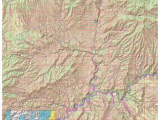
One thing about the maps I make is that they are designed to be used with the Avenza Maps App. This app was once called PDF Maps and was totally free when they came out 10 years ago or so. As they evolved, they became a subscription service with their Pro version however they still offer a free version with really the biggest limitation being that you are limited to just 3 maps in their map app storage location and that maps downloaded from the Avenza Map Store can only be used on their app.. Really, they are the only entity that offers a real-time gps service when reading geo referenced pdf products. However, I also provide these geo referenced maps from my site, and when downloaded go to your download file on you phone. You have complete control of the product you purchased and have the ability to move to any folder you create. Thus, you can also choose to open this geo referenced map in any app that reads Adobe. Furthermore, Adobe offers a free plugin in which you can manipulate locations on screen or choose to print the map. Many of my maps are created in a friendly poster layout. At this time, only the Avenza Map app has real-time gps capabilities. Its crazy but Avenza has the right and trademarks (monopoly) as the only service for real-time GPS.
One other thing.... the majority of the maps I create are designed so as a person can have them printed anywhere where they use large format printers. Printing is not cheap especially if you have it laminated. It can cost you 20 bucks or more for a 17x22 poster onwards to 40-50 bucks for a 36x42. I hesitate printing maps for a customer mainly because the shipping adds a lot to the printing cost however, I have recently printed and shipped a map to Colorado.
So that’s a little about us here at Hi Tech Hunting LLC (SwHuntingMaps.com). Again I really emphasize the one on one interaction in getting you what you want and what you think will work best for you so email me, text me or give me a call. If I don’t answer please leave a message. Thanks again!
Ed Holloway
575-590-7843
hitechhunting@gmail.com